IMAP is an online application that allows underground facility owners to view, add, modify and delete polygons from their active database.
Sign Up for IMAP
Contact Kate Dwyer at kdwyer@occinc.com or call her at 732-394-3000How It Works
- The user wants to create a new coverage area within the base map for future notifications for a specific area(s); they log in to IMAP.
- After logging into the IMAP system, the user activates a series of grids in the base map showing the whereabouts of a particular facility. This process allows them to be notified when work is being done near this area through OCC’s PRISM technology.
- After the new grids have been activated, PRISM works with this information, so when a ticket is filed in the same area as the newly added facility, the user is directly informed.
New Jersey IMAP Manual (PDF)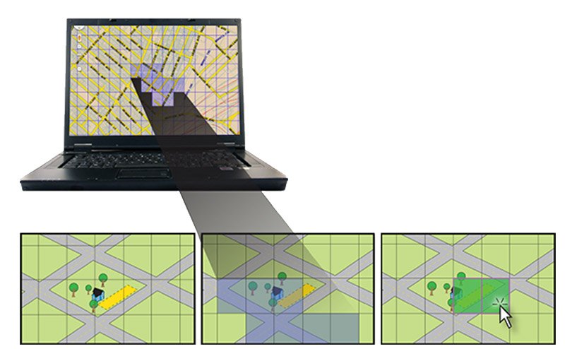 In this series of illustrations, the excavation area is shown in yellow (left), and the facility owner’s coverage area is shown in blue (center). When an excavator files a ticket (right), he selects grids on the map to encompass his excavation area (grids selected are shown here in green). Since the excavator’s mapped area overlaps the facility owner’s coverage area, the facility owner will be notified automatically.
In this series of illustrations, the excavation area is shown in yellow (left), and the facility owner’s coverage area is shown in blue (center). When an excavator files a ticket (right), he selects grids on the map to encompass his excavation area (grids selected are shown here in green). Since the excavator’s mapped area overlaps the facility owner’s coverage area, the facility owner will be notified automatically.